Table of contents
Tulum, originally called Zama ("dawn" in Yucatec Maya), was an active Mayan commercial port between 1200 and 1450 AD during the late Postclassic period. The walled city traded obsidian, jade and cacao along the Caribbean coast of the Yucatan Peninsula. Juan de Grijalva sighted it from the sea in 1518. After centuries of abandonment and decades as a fishing village, Tulum experienced a tourism boom starting in the 2000s that transformed it from a settlement of 6,733 inhabitants (2000 census) to a municipality of 46,721 residents (INEGI 2020 census) with its own international airport inaugurated in December 2023.
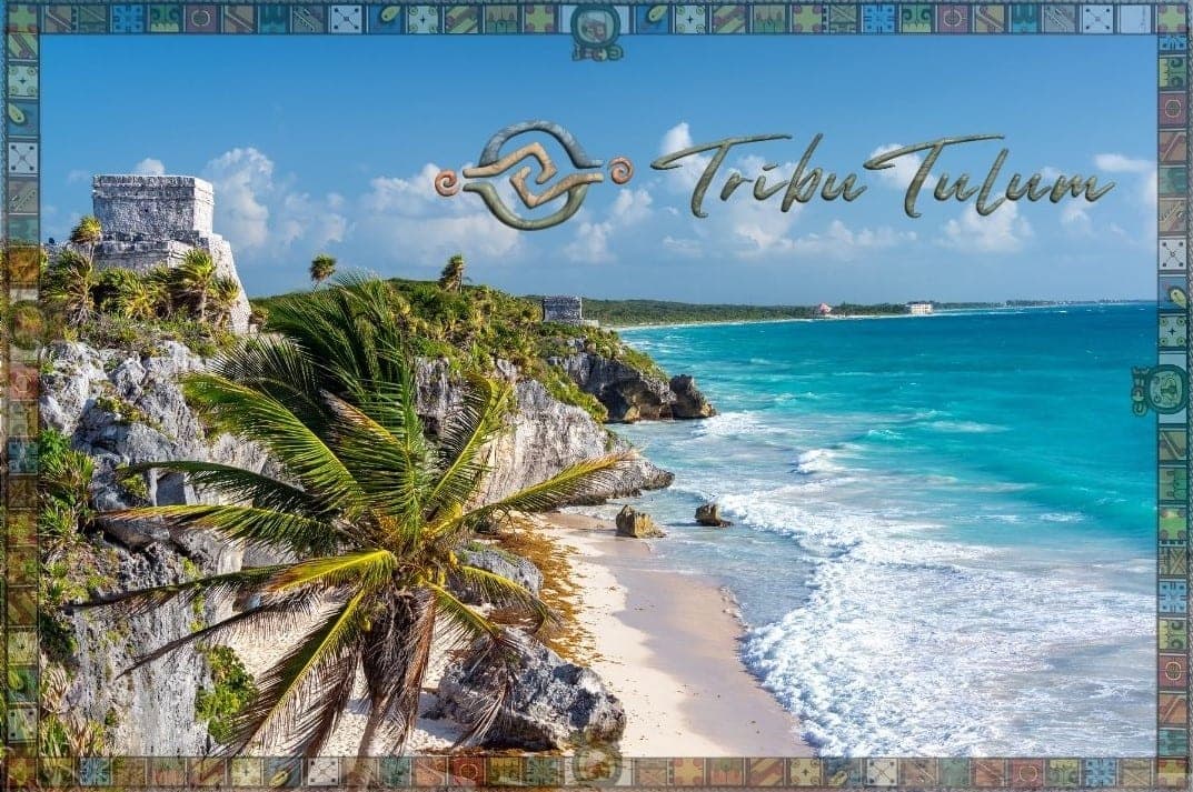
Mayan Tulum: The Trading Port That Faced the Dawn (1200-1450 AD)#
The name "Tulum" means "wall" or "fence" in Maya, a direct reference to the fortification that protected the city on three sides with limestone walls 5 meters high and between 3 and 5 meters thick. The fourth side needed no wall: a natural 12-meter cliff above the Caribbean functioned as both defense and observation platform. The city had 5 narrow entrances that controlled access, confirming its simultaneous function as a commercial center and defensive enclave.
Zama was the original name of the city, which in Yucatec Maya means "place of the dawn." The name was literal: Tulum is the only major Mayan settlement built facing the sea on the eastern coast, and each morning it received the first rays of the Caribbean sun. El Castillo, the tallest structure on the site at 7.5 meters, functioned as a maritime lighthouse. The Maya lit fires at its top to guide merchant canoes navigating the coastal route between Honduras and the Yucatan Peninsula.
Tulum's Mayan trading port operated within an exchange network that moved obsidian from the Guatemalan highlands, jade from the Motagua region, cacao from the Soconusco and Tabasco, salt from Yucatan's northern coastal salt flats, and honey from native melipona bees. Trading canoes, capable of transporting up to 2 tons of cargo, connected Tulum with ports such as Xcaret, Xel-Ha, Isla Mujeres and the island of Cozumel, which functioned as a sanctuary of the goddess Ixchel and a pilgrimage center.
The population within the walls is estimated at between 1,000 and 1,600 inhabitants, composed of merchants, priests and the ruling elite. Outside the walls lived farmers, fishermen and artisans in a broader dispersed area. Interior structures include the Temple of the Frescoes, decorated with polychrome murals representing Mayan deities and offerings, and the Temple of the Descending God, whose inverted figure possibly symbolizes the god of sunset, bees or rain.
The Encounter with Europe: Discovery and Decline (1518-1800)#
On May 3, 1518, the Spanish expedition of Juan de Grijalva sighted Tulum from the sea while navigating the eastern coast of the peninsula. The chronicler Juan Diaz recorded that the city was "as large as Seville," a comparison probably exaggerated but indicative that Tulum still maintained significant activity. The buildings painted in vivid colors -- red, blue and yellow -- were visible from the vessels.
The Spanish did not disembark on that first contact. The conquest of the Mayan region of Quintana Roo was a slow process that extended throughout the 16th century. Epidemics of smallpox, measles and other European diseases decimated the native population of the peninsula by between 75% and 90% during the first 100 years of contact. Tulum was gradually abandoned toward the end of the 16th century, although there are records of sporadic ceremonial use into the 17th century.
During the 17th and 18th centuries, the subtropical jungle reclaimed the city stone by stone. The roots of ramon and chicozapote trees enveloped the walls. Lianas covered the temples. Tulum disappeared from the European map for nearly 300 years.
Rediscovery and Exploration: Stephens, Catherwood and Fame (1842-1950)#
In 1842, American explorer John Lloyd Stephens and British artist Frederick Catherwood arrived at Tulum as part of their second journey through the Mayan ruins of Central America. Catherwood produced detailed drawings of El Castillo, the Temple of the Frescoes and the walls, published in the book Incidents of Travel in Yucatan (1843). These illustrations were the first images of Tulum to reach European and North American audiences, generating academic interest in Mayan civilization.
In 1913, archaeologists Sylvanus Morley and Jesse Nusbaum from the Carnegie Institution conducted the first systematic study of Tulum, producing maps, photographs and detailed descriptions. Morley classified Tulum as a late Postclassic site, differentiating it from the great Classic centers like Tikal or Palenque. Throughout the 20th century, INAH (National Institute of Anthropology and History) research expanded understanding of the site's commercial and astronomical function.
From Fishing Village to Backpacker Paradise (1960-2000)#
Until the 1960s, Tulum was an isolated community of Mayan fishermen and chicleros (chicozapote resin harvesters). No paved road existed. Electricity arrived in the town in the 1970s. Access was only by dirt roads or by sea.
The construction of Federal Highway 307 (Cancun-Chetumal) in the 1970s opened Tulum to the outside world. The first visitors were European and North American backpackers seeking virgin beaches far from the mass tourism of Cancun, which had been founded as a government tourism project in 1970. In the 1980s and 1990s, rustic palapa cabanas without electricity or running water cost between $5 and $15 USD per night along the coastal road.
Tulum town functioned as a supply point: a few shops, a market, a school and a church. The local economy depended on fishing, subsistence agriculture (milpa) and incipient budget tourism. The 2000 census recorded 6,733 inhabitants in the locality.
The Tourism Boom: How Tulum Became a Global Destination (2000-Present)#
Tulum's transformation accelerated from the year 2000 with three differentiated phases. The first phase (2000-2010) brought eco-tourism and the first boutique hotels. Properties like Papaya Playa Project, Be Tulum and Coqui Coqui established the "rustic luxury" model that would define the Tulum brand: natural materials, organic design, connection with jungle and sea. The coastal hotel zone began to appreciate in value.
The second phase (2010-2018) saw the social media explosion. Instagram transformed Tulum into one of the most photographed destinations in the world. The hashtag #Tulum accumulated hundreds of millions of posts. Hotels, restaurants and beach clubs competed to create "Instagrammable" spaces. Real estate investment skyrocketed: neighborhoods like Aldea Zama, La Veleta and Region 15 emerged to house condominiums and residential developments.
The third phase (2018-present) consolidated luxury tourism and foreign investment. Tulum was declared an independent municipality in 2008, separating from Solidaridad (Playa del Carmen). The population grew from 6,733 (2000) to 28,263 (2010) and to 46,721 (2020), a 594% increase in two decades. The Felipe Carrillo Puerto International Airport (IATA code: TQO) opened on December 1, 2023, located 20 km southwest of the city. The Tren Maya station connected Tulum with Cancun, Merida and other Peninsula destinations starting in 2024.
The tourism boom also brought negative impacts: the underground aquifer faces contamination due to lack of drainage in much of the urban and hotel areas, sargassum has affected beaches recurrently since 2018, and real estate development has fragmented jungle and mangrove ecosystems.
What Is Tulum's Future? Challenges and Opportunities#
Tulum faces permanent tension between economic growth and environmental sustainability. Real estate oversupply pressures prices downward in the vacation rental market, while public infrastructure (water, drainage, roads) has not grown at the pace of private construction. The municipal government and civil organizations are working on wastewater treatment projects and protection of the underground cenote system.
The opening of the airport and the Tren Maya position Tulum as a direct-connectivity destination, reducing the historical dependence on Cancun. The Sian Ka'an Biosphere Reserve (528,000 hectares, UNESCO Heritage since 1987) south of the city functions as a natural limit to development and as a high-value ecotourism asset. The balance between preserving Mayan cultural identity, protecting ecosystems and managing tourism growth defines the next chapter of Tulum's history.
Where Can You See Tulum's History Today?#
The archaeological zone of Tulum, administered by INAH, receives more than 2 million annual visitors and is the third most visited archaeological site in Mexico. The ruins are located on the coastal cliff, 2 km from the coastal road. You can visit the Tulum ruins any day from 8:00 AM to 5:00 PM; entrance costs $95 MXN for national visitors and an additional $90 MXN for foreigners.
The Mayan heritage does not end at the archaeological zone. Contemporary Mayan communities in the region maintain traditions such as the Hanal Pixan ceremony (Mayan Day of the Dead), milpa cultivation and melipona beekeeping. Living Mayan culture in Tulum is manifested in the Yucatec Maya language, spoken by more than 800,000 people on the peninsula, in regional gastronomy and in ceremonies still practiced by the j-men (traditional Mayan priests).
For those considering moving, the guide to moving to Tulum details cost of living, legal requirements and recommendations for the transition.