Table of contents
Cenotes form through karst dissolution of limestone when rainwater, slightly acidified by absorbing atmospheric CO2, penetrates the rock over thousands of years, creating underground caverns. When the cavern roof collapses, an open cenote is formed. The Yucatan Peninsula concentrates over 6,000 documented cenotes because its geological base is pure Cretaceous limestone (65+ million years old), fractured by the Chicxulub meteorite impact 66 million years ago. This impact created a crater 180 km in diameter and a ring of cenotes visible from satellite that delineates the zone of greatest fracturing.
What Is a Cenote from a Geological Perspective?#
A cenote is a collapse sinkhole in karst topography: a natural depression formed when the roof of an underground limestone cavern gives way under its own weight, exposing the underground aquifer. The precise geological term is "karst collapse sinkhole," classified among the landforms characteristic of regions where soluble limestone dominates the surface geology.
The limestone (calcium carbonate, CaCO3) composing 100% of the peninsular surface formed as marine carbonate sediment during the Cretaceous period, when the Yucatan Peninsula lay beneath a shallow sea. This limestone platform has a thickness of 1,000 to 3,000 meters and lacks any surface rivers: all rainfall (annual average of 1,200 mm in the Tulum area) infiltrates directly through the porous rock into the underground aquifer.
Karst dissolution occurs when rainwater absorbs carbon dioxide (CO2) from the soil, forming weak carbonic acid (H2CO3) that reacts with calcium carbonate. The reaction: CaCO3 + H2CO3 -> Ca(HCO3)2 (soluble calcium bicarbonate) dissolves rock at rates of 0.01-0.1 mm per year. Over tens of thousands of years, this process creates caverns, tunnels, and eventually cenotes.
The Chicxulub Impact: The Meteorite That Created the Cenotes#
Sixty-six million years ago, an asteroid 10-15 km in diameter struck the Yucatan Peninsula at an estimated speed of 20 km/s, creating the Chicxulub crater. This event -- the same one that caused the Cretaceous-Paleogene mass extinction and the disappearance of the dinosaurs -- fractured the peninsula's limestone in radial and concentric patterns that today determine the distribution of cenotes.
The Chicxulub crater measures 180 km in diameter at its internal structure (the most recent evidence suggests up to 300 km for the external structure). The energy released was equivalent to 10 billion Hiroshima bombs (4.2 x 10^23 joules). The impact generated a 1,500-meter-high tsunami, magnitude 11+ earthquakes, and ejected 25 trillion tons of rock into the atmosphere.
The limestone fracturing concentrated around the crater's perimeter, creating the ring of cenotes: a semicircular alignment of cenotes approximately 165 km in diameter that delineates the crater's edge. This cenote ring is visible in satellite images as a chain of green dots (denser vegetation due to water access) across the peninsula's flat terrain. UNESCO has had the ring of cenotes on its Tentative World Heritage List since 1999.
Fracturing from the impact increased limestone permeability up to 100 times compared to unfractured rock. This accelerated water infiltration and cavern formation along the fracture lines, concentrating cenotes in specific zones.
The Formation Process: From Solid Rock to Flooded Cave#
Cenote formation follows five geological stages, developing over tens to hundreds of thousands of years:
-
Limestone deposition (Cretaceous period, 145-66 million years ago): Marine calcium carbonate sediments accumulate in layers up to 3,000 meters thick on the Yucatecan continental platform. Shells, corals, and marine organisms form the raw material of the limestone.
-
Chicxulub impact fractures the rock (66 million years ago): The asteroid generates radial and concentric fractures in the limestone platform. These fractures create preferential pathways for water infiltration. The zone of greatest fracturing (crater perimeter) will have the highest cenote density.
-
Acidic water infiltration dissolves the limestone (last 130,000 years): During interglacial periods with high sea levels, CO2-charged rainwater penetrates the fractures and dissolves the limestone. The process forms conduits, tunnels, and eventually underground caverns. Dissolution rate: 0.01-0.1 mm/year.
-
Underground cavern formation (tens of thousands of years): Tunnels widen to form chambers tens of meters in diameter and depth. In dry caverns (above the water table), water dripping deposits calcium carbonate forming stalactites (ceiling) and stalagmites (floor) at a rate of approximately 1 cm every 100 years.
-
Roof collapse = open cenote (thousands of years to days): When the cavern roof thins sufficiently, it collapses under its own weight, creating an opening to the sky. This collapse can be gradual (continuous erosion) or sudden (earthquake, vegetation load). The resulting cenote exposes the underground aquifer.
The 4 Types of Cenotes by Formation Stage#
The geological classification of cenotes reflects progressive evolutionary stages:
-
Cave-type cenote (young cenote): The cavern maintains its intact roof. Access requires descending through a narrow lateral or vertical entrance. Total darkness inside. Intact stalactites and stalagmites. Example: Sac Actun System (371+ km of subaquatic passages, the world's longest flooded cave system).
-
Semi-open cenote (transitional cenote): Part of the roof has collapsed, allowing partial light entry. Tree roots penetrate from the surface. Combination of illuminated and dark zones. Example: Cenote Dos Ojos, with two openings to the sky.
-
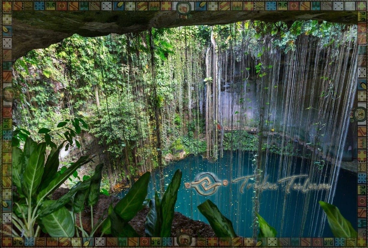
Open cenote (mature cenote): The roof has completely collapsed. Vertical limestone walls surround a water mirror exposed to the sky. Tropical vegetation hangs from the edges. Example: Cenote Ik Kil (60 m diameter, 40 m depth).
-
Aguada or lagoon-type cenote (old cenote): Walls have eroded and flattened. The cenote has become a lagoon or shallow depression. Vegetation covers the edges. Example: Laguna Kaan Luum, 10 km south of Tulum.
The Chicxulub Cenote Ring: Visible from Space#
The cenote ring delineates the northwestern perimeter of the Chicxulub crater with a diameter of 165 +/- 5 km. This formation concentrates over 900 cenotes aligned in a semicircular arc visible in satellite images and aerial photographs. Cenote density within the ring exceeds 10 cenotes per km2 in some zones.
The ring's geophysics reveals critical differences: outside the ring, unfractured limestone has low permeability and few cenotes. Inside the ring, impact fracturing created a network of conduits through which water circulates more easily, forming the peninsula's deepest cenotes (150+ meters).
The Sac Actun System, with 371+ km of mapped subaquatic passages, represents the greatest expression of this karst system. Divers from the Gran Acuifero Maya (GAM) project have documented underground connections between cenotes separated by kilometers on the surface, confirming that the Yucatan Peninsula harbors an interconnected hydrological system unique on the planet.
Visit Cenotes with a Geologist's Eyes#
Understanding the geology transforms the experience of swimming in a cenote: each stalactite, each root penetrating the roof, each rock formation tells a story spanning millions of years. The cenotes you can visit today in Tulum exhibit all four geological formation stages. The meaning of cenotes for the Maya adds a cultural dimension to the geological wonder. Adventurers can experience the karst system firsthand through diving in the world's largest cave system.